大家好,又见面了,我是你们的朋友全栈君。
目录
Landsat 9 Instruments: Pushing into the future
1.基本情况
Landsat 9号是Landsat系列中最新的一颗卫星,计划于2020年12月在加利福利亚范登堡空军基地由Atlas V 401火箭搭载进行发射,实际于于2021年9月27日发射,并已经开始采集第一批数据,2021年10月31日获取到遥感数据。Landsat9是继续Landsat系列对地球表面观测不可替代的记录。为了减少建造时间和观测缺口的风险,Landsat 9在很大程度上复制了它的前身Landsat 8。
来源:原文链接
2.Landsat9数据介绍
2.1 Landsat系列波段信息图谱
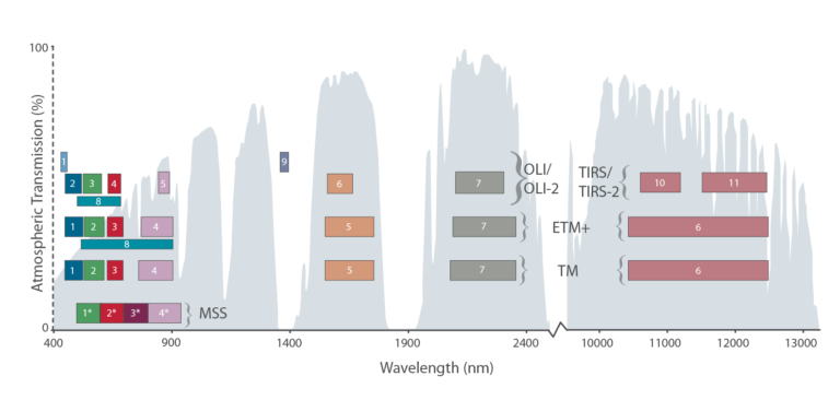

The Multispectral Scanner System (MSS) aboard Landsats 1–5 had four bands. The Thematic Mapper (TM) aboard Landsats 4 & 5 had seven bands. Landsat 7’s Enhanced Thematic Mapper Plus (ETM+) has 8 bands and Landsats 8 & 9 have 11 bands. The atmospheric transmission values for this graphic were calculated using MODTRAN for a summertime mid-latitude hazy atmosphere (circa 5 km visibility).
Landsats 1-5 上的多光谱扫描仪系统 (MSS) 有四个波段。 Landsats 4 和 5 上的 Thematic Mapper (TM) 有七个波段。 Landsat 7 的 Enhanced Thematic Mapper Plus (ETM+) 有 8 个频段,而 Landsat 8 和 9 有 11 个频段。 该图形的大气透射值是使用 MODTRAN 针对夏季中纬度朦胧大气(能见度约 5 公里)计算得出的。
2.2 Landsat9基本信息
2.2.1 Quick Facts
- Science Instruments: OLI-2; TIRS-2
- OLI-2 build: Ball Aerospace & Technology Corp.
- TIRS-2 build: NASA Goddard Space Flight Center
- Design Life: 5 years
- Spacecraft Provider:Northrop Grumman
- Image Data: > 700 scenes per day
- Launch Date: Sept. 27, 2021
- Launch Vehicle: United Launch Alliance Atlas V 401
- Orbit: near-polar, sun-synchronous at an altitude of 438 miles (705 km)
- Orbital Inclination: 98.2˚
- Spacecraft Speed: 16,760 mi/hr (26,972 km/hr),
- Consumables: 10 years
速览:
科学仪器:OLI-2; TIRS-2
OLI-2 版本:Ball Aerospace & Technology Corp.
TIRS-2 建造:美国宇航局戈达德太空飞行中心
设计寿命:5 年
航天器供应商:Northrop Grumman
图像数据:> 每天 700 个场景
发布日期:2021 年 9 月 27 日
运载火箭:联合发射联盟 Atlas V 401
轨道:近极地,在 438 英里(705 公里)的高度与太阳同步
轨道倾角:98.2˚
航天器速度:16,760 英里/小时(26,972 公里/小时),
消耗期:10 年
2.2.2 LANDSAT9 波段信息
Landsat9波段信息和Landsat8基本一致,传感器性能有所提高。
Landsat9波段信息:
-
波段1可见(0.43-0.45μm)30m
-
波段2可见(0.450-0.51μm)30m
-
波段3可见(0.53-0.59μm)30m
-
波段4红色(0.64-0.67μm)30m
-
波段5近红外(0.85-0.88μm)30m
-
波段6 swir 1(1.57-1.65μm)30m
-
波段7 swir 2(2.11-2.29μm)30m
-
波段8全色(PAN)(0.50-0.68μm)15m
-
波段9卷云(1.36-1.38μm)30m
-
波段10 TIRS 1(10.6-11.19μm)100m
-
波段11 TIRS 2(11.5-12.51μm)100m

Coastal/Aerosol Band (Band 1)
This band helps scientists measure chlorophyll concentrations (ocean color) in coastal regions. Most of the chlorophyll comes from phytoplankton, tiny plant-like organisms that live in surface waters. This band is also useful for aerosol detection.
沿海/气溶胶波段(波段 1)
该波段可帮助科学家测量沿海地区的叶绿素浓度(海洋颜色)。 大多数叶绿素来自浮游植物,它们是生活在地表水中的微小植物状生物。 该波段也可用于气溶胶检测。

Cirrus Band (Band 9)
High, thin cirrus clouds can be hard to spot in satellite images. Both the clouds and their shadows can interfere with measurements. Landsats 8 and 9 are designed to detect these clouds by measuring light in the part of the electromagnetic spectrum where the clouds are most visible.
卷云波段(波段 9)
在卫星图像中很难发现又高又薄的卷云。 云和它们的阴影都会干扰测量。 Landsats 8 和 9 旨在通过测量云最可见的电磁光谱部分中的光来检测这些云。
Two Thermal Infrared Bands (Bands 10 & 11)
Everything on Earth emits thermal infrared radiation. The amount of emitted radiation depends on the object’s temperature. Landsat 9, like Landsat 8, images data for two distinct thermal infrared spectral regions. The stray light issues that have plagued Landsat 8 were corrected for Landsat 9.
两个热红外波段(波段 10 和 11)
地球上的一切都发出热红外辐射。 发射的辐射量取决于物体的温度。 Landsat 9 与 Landsat 8 一样,对两个不同的热红外光谱区域的数据进行成像。 困扰 Landsat 8 的杂散光问题。
Landsat8数据波段信息:
|
传感器类型 |
波段 |
波长范围(μm) |
空间分辨率(m) |
主要应用 |
|---|---|---|---|---|
|
陆地成像仪OLI |
Band 1 Coastal(海岸波段) |
0.433–0.453 |
30 |
主要用于海岸带观测 |
|
Band 2 Blue(蓝波段) |
0.450–0.515 |
30 |
用于水体穿透,分辨土壤植被 |
|
|
Band 3 Green(绿波段) |
0.525–0.600 |
30 |
用于分辨植被 |
|
|
Band 4 Red(红波段) |
0.630–0.680 |
30 |
处于叶绿素吸收区,用于观测道路,裸露土壤,植被种类等 |
|
|
Band 5 NIR(近红外波段) |
0.845–0.885 |
30 |
用于估算生物量,分辨潮湿土壤 |
|
|
Band 6 SWIR 1(短波红外1) |
1.560–1.660 |
30 |
用于分辨道路,裸露土壤,水,还能在不同植被之间有好的对比度,并且有较好的大气、云雾分辨能力 |
|
|
Band 7 SWIR 2(短波红外2) |
2.100–2.300 |
30 |
用于岩石,矿物的分辨很有用,也可用于辨识植被覆盖和湿润土壤 |
|
|
Band 8 Pan(全色波段) |
0.500–0.680 |
15 |
为15米分辨率的黑白图像,用于增强分辨率 |
|
|
Band 9 Cirrus(卷云波段) |
1.360–1.390 |
30 |
包含水汽强吸收特征,可用于云检测 |
|
|
热红外传感器TIRS |
Band 10 TIRS 1(热红外1) |
10.60 -11.19 |
100 |
感应热辐射的目标 |
|
Band 11 TIRS 2(热红外2) |
11.50 -12.51 |
100 |
感应热辐射的目标 |
Landsat 8 and Landsat 9’s innovative design make them more sensitive and more reliable than earlier Landsat satellites.
Their pushbroom architecture gives the satellites more dwell time over the ground, which leads to a better signal-to-noise ratio. That means you can see (and computers can detect) more nuanced details in the images.
The slider image comparison on the right shows a subsection a Landsat 8 OLI image (left) and a Landsat 7 Enhanced Thematic Mapper Plus (ETM+) acquired on same day during an underflight conducted as Landsat 8 made its way up to its nominal orbit. To achieve greater sensitivity to brightness and color, the OLI instruments (as well as the Thermal Infrared Sensors) on Landsats 8 were designed to produce 12-bit data— Landsat 9’s OLI-2 and TIRS-2 will have 14-bit resolution.Landsat 9’s 14-bit data for OLI-2 and TIRS-2 increases that to 16,384 data values.
google翻译:
Landsat 8 和 Landsat 9 的创新设计使它们比早期的 Landsat 卫星更灵敏、更可靠。
他们的推扫式架构为卫星提供了更多的地面停留时间,从而获得更好的信噪比。 这意味着您可以在图像中看到(并且计算机可以检测到)更细微的细节。
右侧的滑块图像比较显示了 Landsat 8 OLI 图像(左)和 Landsat 7 Enhanced Thematic Mapper Plus (ETM+) 在同一天在 Landsat 8 进入其标称轨道时进行的飞行期间获取的子部分。 为了实现对亮度和颜色的更高灵敏度,Landsat 8 上的 OLI 仪器(以及热红外传感器)设计为产生 12 位数据——Landsat 9 的 OLI-2 和 TIRS-2 将具有 14 位分辨率。Landsat 9 的 OLI-2 和 TIRS-2 的 14 位数据将其增加到 16,384 个数据值。
The previous generation sensor, ETM+, supports 8-bit data products, which means means the brightest to the darkest pixels are discriminated with 256 data values. The greater sensitivity of OLI and TIRS allow the signal to be discriminated over 4096 data values, the range was increased to prevent saturation of very bright targets such as snow.
The practical effect of this refinement is apparent when comparing the OLI and ETM+ of Wickiup Reservoir Cascade Mountains of the Pacific Northwest: OLI shows more nuanced details in the shoreline and marshlands of the shallow Wickiup Reservoir, while at the same time showing more contrast in the snow and ice of Davis Mountain.
google翻译:
上一代传感器 ETM+ 支持 8 位数据产品,这意味着最亮到最暗的像素由 256 个数据值区分。 OLI 和 TIRS 的更高灵敏度允许区分超过 4096 个数据值的信号,范围增加以防止非常明亮的目标(如雪)饱和。
当比较太平洋西北部 Wickiup Reservoir Cascade Mountains 的 OLI 和 ETM+ 时,这种改进的实际效果是显而易见的:OLI 在浅水 Wickiup 水库的海岸线和沼泽地中显示出更细微的细节,同时在 戴维斯山的冰
3.其他信息
3.1 设备信息
Landsat 9 Instruments: Pushing into the future

Linear detector arrays, like the ones on Landsats 8 and 9, image across the entire image swath at once. (Adapted from Aronoff, 2005.)
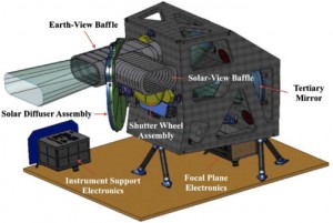
Landsat instruments used to collect data by sweeping back and forth across the image swath like a whisk broom. The sensor looked at a calibration source at the end of every row, making measurements consistent from row-to-row and orbit-to-orbit. But this type of design required fast-moving parts, which are more likely to break—and which did on Landsat 7. Both instruments on Landsat 9, like Landsat 8, will view across the entire swath at once, building strips of data like a pushbroom. This approach requires no moving parts and gives the sensor detectors greater dwell time. The pushbroom instrument is smaller and lighter than previous whisk broom instruments, but its calibration is much more complex given the large number of detectors. Landsat 9 will fly near-identical copies of the Operational Land Imager (OLI) and Thermal Infrared Sensor (TIRS) instruments that were flown on Landsat 8. The TIRS instrument will be upgraded to a risk class B implementation, whereas no changes are planned for OLI. With respect to the Landsat 9 project, these instruments will be referred to as OLI-2 and TIRS-2.
Google翻译:Landsat 仪器用于通过像扫帚一样来回扫过图像条来收集数据。传感器查看每一行末尾的校准源,使行到行和轨道到轨道的测量保持一致。但是这种类型的设计需要快速移动的部件,这些部件更容易损坏——在 Landsat 7 上就是这样。 Landsat 9 上的两种仪器,如 Landsat 8,将同时查看整个条带,构建数据条带推扫帚。这种方法不需要移动部件,并为传感器探测器提供更长的停留时间。推扫式仪器比以前的扫帚式仪器更小、更轻,但鉴于探测器数量众多,其校准要复杂得多。 Landsat 9 将飞行在 Landsat 8 上飞行的操作陆地成像仪 (OLI) 和热红外传感器 (TIRS) 仪器的几乎相同副本。奥利。对于 Landsat 9 项目,这些仪器将被称为 OLI-2 和 TIRS-2。

Line by line, Landsat 9’s pushbroom instruments will collect data around the globe. Image credits: NASA Earth Observatory.
Operational Land Imager 2
The Ball Aerospace & Technologies Corporation is building Landsat 9’s Operational Land Imager 2 (OLI-2). OLI-2 will take measurements in the visible, near infrared, and shortwave infrared portions of the electromagnetic spectrum. The spatial resolution of its images will be 15 m (49 ft) for the panchromatic band and 30 m (98 ft) for the multispectral bands. The image swath will be 185 km (115 mi) wide, covering wide areas of the Earth’s landscape while providing sufficient resolution to distinguish land cover features like urban centers, farms, and forests. Landsat 9’s near-polar orbit precesses at the same rate the Earth rotates around the sun, allowing the entire Earth to fall within view every 16 days at the same local solar time.
Google翻译:Ball Aerospace & Technologies Corporation 正在建造 Landsat 9 的操作陆地成像仪 2 (OLI-2)。 OLI-2 将在电磁波谱的可见光、近红外和短波红外部分进行测量。 其图像的空间分辨率对于全色波段为 15 m(49 英尺),对于多光谱波段为 30 m(98 英尺)。 图像条带将有 185 公里(115 英里)宽,覆盖地球景观的广阔区域,同时提供足够的分辨率来区分城市中心、农场和森林等土地覆盖特征。 Landsat 9 的近极轨道以地球绕太阳旋转的相同速度进动,使整个地球每 16 天在同一当地太阳时进入视野。
OLI-2 Design The OLI-2 design is a copy of Landsat 8’s OLI. The OLI-2 instrument will provide visible and near infrared / shortwave infrared (VNIR/SWIR) imagery consistent with previous Landsat spectral, spatial, radiometric and geometric qualities. A difference, however, is that Landsat 9 will downlink all 14 bits of data produced by OLI-2, providing a greater bit depth for its imagery as compared to the 12-bit data downlinked from Landsat 8’s OLI. An impact of this change is that OLI-2 will provide additional, useful information for dark targets (e.g. dense forests). The OLI-2 instrument includes an optical telescope, Focal Plane Array / Focal Plane Electronics (FPA/FPE), calibration hardware, and instrument support electronics. OLI-2 will provide data for nine spectral bands with a maximum ground sampling distance (GSD), both in-track and cross track, of 30 m (98 ft) for all bands except the panchromatic band, which has a 15 m (49 ft) GSD. OLI-2 will provide both internal calibration sources to ensure radiometric accuracy and stability, as well as the ability to perform solar and lunar calibrations.
Google翻译:OLI-2 设计是 Landsat 8 的 OLI 的副本。 OLI-2 仪器将提供与先前 Landsat 光谱、空间、辐射测量和几何质量一致的可见光和近红外/短波红外 (VNIR/SWIR) 图像。然而,不同之处在于,Landsat 9 将下行链接 OLI-2 产生的所有 14 位数据,与从 Landsat 8 的 OLI 下行链接的 12 位数据相比,为其图像提供更大的位深度。这一变化的一个影响是 OLI-2 将为黑暗目标(例如茂密的森林)提供额外的、有用的信息。 OLI-2 仪器包括光学望远镜、焦平面阵列/焦平面电子设备 (FPA/FPE)、校准硬件和仪器支持电子设备。 OLI-2 将提供 9 个光谱带的数据,其中最大地面采样距离 (GSD),包括轨道内和跨轨道,对于除全色带之外的所有波段均为 30 m(98 英尺),全色波段具有 15 m(49英尺) GSD。 OLI-2 将提供内部校准源以确保辐射测量的准确性和稳定性,以及执行太阳和月球校准的能力。
Thermal Infrared Sensor 2
Landsat 9’s Thermal Infrared Sensor 2 (TIRS-2) will measure land surface temperature in two thermal infrared bands using the same technology that was used for TIRS on Landsat 8, which uses principles of quantum physics to measure emissions of infrared energy. TIRS-2 will be an improved version of Landsat 8’s TIRS, both with regards to instrument class and stray light reduction (see below). However, both the design and specs for TIRS-2 will remain closely aligned with that of TIRS. The TIRS-2 instrument will be a two-band thermal imaging sensor that will provide imagery consistent with Landsat 8 thermal spectral, spatial, radiometric and geometric qualities to enable consistent retrieval of surface temperature. TIRS-2 will provide two spectral bands with a maximum ground sampling distance, both in-track and cross track, of 100 m (328 ft) for both bands. TIRS-2 provides an internal blackbody calibration source as well as space view capabilities.
Google翻译:Landsat 9 的热红外传感器 2 (TIRS-2) 将使用与 Landsat 8 上的 TIRS 相同的技术测量两个热红外波段的地表温度,该技术使用量子物理学原理来测量红外能量的发射。 TIRS-2 将是 Landsat 8 TIRS 的改进版本,无论是在仪器等级还是杂散光减少方面(见下文)。 但是,TIRS-2 的设计和规格仍将与 TIRS 的设计和规格保持一致。 TIRS-2 仪器将是一个双波段热成像传感器,将提供与 Landsat 8 热光谱、空间、辐射测量和几何质量一致的图像,以实现对表面温度的一致检索。 TIRS-2 将提供两个光谱波段,两个波段的最大地面采样距离(轨道内和交叉轨道)均为 100 m(328 英尺)。 TIRS-2 提供内部黑体校准源以及空间查看功能。
Now That’s Classy On Landsat 9, OLI-2 and TIRS-2 will both have a five-year design life. Because of the very limited build time for Landsat 8’s TIRS instrument, it was built with a three-year design life.
Get the Ghost Out Landsat 8’s TIRS instrument has a stray light issue that is allowing light outside the image to reach the focal plane and reduce the accuracy of its thermal measurements, especially for Band 11. This will be remedied in TIRS-2.
现在,在 Landsat 9 上,OLI-2 和 TIRS-2 都将拥有五年的设计寿命。 由于 Landsat 8 的 TIRS 仪器的构建时间非常有限,因此它的设计寿命为三年。
消除 Landsat 8 的 TIRS 仪器存在的杂散光问题,该问题允许图像外的光到达焦平面并降低其热测量的准确性,尤其是对于波段 11。这将在 TIRS-2 中得到解决。
OLI Design
Drawing of the Operational Land Imager (Courtesy of Ball Aerospace & Technologies Corporation).
The OLI is a push broom sensor employing a focal plane with long arrays of photosensitive detectors (Irons & Dwyer, 2010). A four-mirror anastigmatic telescope focuses incident radiation onto the focal plane while providing a 15-degree field-of-view covering a 185 km across-track ground swath from the nominal LDCM observatory altitude (Fig 1). Periodic sampling of the across-track detectors as the observatory flies forward along a ground track forms the multispectral digital images. The detectors are divided into 14 modules arranged in an alternating pattern along the centerline of the focal plane (Fig. 2). Data are acquired from nearly 7000 across-track detectors for each spectral band with the exception of the 15 m panchromatic band that requires over 13,000 detectors. The spectral differentiation is achieved by interference filters arranged in a “butcher-block” pattern over the detector arrays in each module. Silicon PIN (SiPIN) detectors collect the data for the visible and near-infrared spectral bands (Bands 1 to 4 and 8) while Mercury–Cadmium–Telluride (MgCdTe) detectors are used for the shortwave infrared bands (Bands 6, 7, and 9).
google翻译:OLI 是一种推扫式传感器,采用焦平面和长阵列光敏探测器 (Irons & Dwyer, 2010)。四镜散像望远镜将入射辐射聚焦到焦平面上,同时提供 15 度视场,覆盖距离标称 LDCM 天文台高度 185 公里的跨轨道地面带(图 1)。随着天文台沿着地面轨道向前飞行,跨轨道探测器的周期性采样形成了多光谱数字图像。探测器被分成 14 个模块,沿着焦平面的中心线以交替模式排列(图 2)。除了需要超过 13,000 个探测器的 15 m 全色波段外,数据是从每个光谱波段的近 7000 个跨轨探测器获取的。光谱差异是通过在每个模块中的探测器阵列上以“屠宰块”模式排列的干涉滤光片实现的。硅 PIN (SiPIN) 探测器收集可见光和近红外光谱波段(波段 1 至 4 和 8)的数据,而汞-镉-碲化物 (MgCdTe) 探测器用于短波红外波段(波段 6、7 和 8)。 9).
Drawing of the OLI focal plane (Courtesy of Ball Aerospace & Technologies Corporation).
The OLI telescope will view the Earth through a baffle extending beyond the aperture stop. A shutter wheel assembly sits between the baffle and the aperture stop. A hole in the shutter wheel will allow light to enter the telescope during nominal observations and the wheel will rotate when commanded to a closed position and act as a shutter preventing light from entering the instrument. A second baffle, for solar views, intersects the Earth-view baffle at a 90° angle and a three-position diffuser wheel assembly dissects the angle. A hole in the diffuser wheel allows light to enter the telescope for nominal Earth observations. Each of the other two wheel positions introduces one of two solar diffuser panels to block the optical path through the Earth-view baffle. When the wheel is in either of these two positions, the solar-view baffle will be pointed at the sun and a diffuser panel will reflect solar illumination into the telescope. One position will hold a “working” panel that will be exposed regularly to sunlight while the other position will hold a “pristine” panel that will be exposed infrequently and used to detect changes in the “working” panel spectral reflectance due to solar exposure. Additionally, two stimulation lamp assemblies will be located just inside the telescope on the aperture stop. The two assemblies will each hold six small lamps inside an integrating hemisphere and will be capable of illuminating the full OLI focal plane through the telescope with the shutter closed. These assemblies, the shutter wheel, diffuser wheel, and stimulation lamp assemblies, constitute the OLI calibration subsystem.
google翻译:OLI 望远镜将通过延伸超出孔径光阑的挡板观察地球。快门轮组件位于挡板和孔径光阑之间。在正常观测期间,快门轮上的一个孔将允许光线进入望远镜,并且在命令到关闭位置时该轮将旋转并充当快门以防止光线进入仪器。用于太阳视图的第二个挡板以 90° 角与地球视图挡板相交,一个三位扩散器轮组件将这个角度剖开。漫射轮上的一个孔允许光线进入望远镜进行名义地球观测。其他两个轮位置中的每一个都引入了两个太阳能扩散板中的一个,以阻挡通过地球视图挡板的光路。当轮子处于这两个位置中的任何一个位置时,太阳视野挡板将指向太阳,并且漫射板将太阳光反射到望远镜中。一个位置将放置一个“工作”面板,该面板将定期暴露在阳光下,而另一个位置将放置一个“原始”面板,该面板将不经常暴露并用于检测由于阳光照射而导致的“工作”面板光谱反射率的变化。此外,两个刺激灯组件将位于孔径光阑上的望远镜内部。这两个组件将每个在积分半球内装有六个小灯,并且能够在快门关闭的情况下通过望远镜照亮整个 OLI 焦平面。这些组件、快门轮、漫射轮和刺激灯组件构成 OLI 校准子系统。
Excerpted from Remote Sensing of Environment 122, James R. Irons, John L. Dwyer, and Julia A. Barsi , The next Landsat satellite: The Landsat Data Continuity Mission, 11-21, Copyright 2012, doi:10.1016/j.rse.2011.08.026, with permission from Elsevier
4.数据下载
Landsat9数据目前成处于检查期,后期将于USGS网站免费共享。
发布者:全栈程序员-用户IM,转载请注明出处:https://javaforall.cn/163496.html原文链接:https://javaforall.cn
【正版授权,激活自己账号】: Jetbrains全家桶Ide使用,1年售后保障,每天仅需1毛
【官方授权 正版激活】: 官方授权 正版激活 支持Jetbrains家族下所有IDE 使用个人JB账号...